
Link profiles are used for many different applications within the telecommunications industry. Network planners, hardware companies, wireless internet service providers, and traditional carriers all have a use for link profiles. Network planners use link profiles to plan tower locations, ensuring that there are no obstructions between the towers. Hardware companies use link profiles to assist in decision making for what transmitter specifications, notably frequency, would be best suited for installation on a particular tower. Wireless internet service providers and traditional carriers use link profiles to assess whether an address can be serviced with their existing network. Link profiles can also be used as a terrain analytic to evaluate terrain and visualize obstructions between two points.
Components of Link Profiles
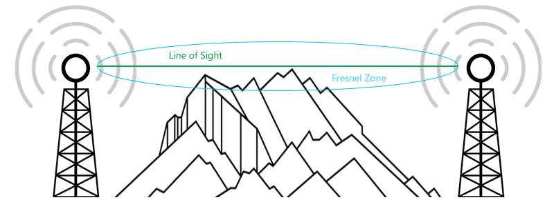
Fresnel Zone
One important factor in a link profile is the Fresnel zone. It is the ellipsoidal-shaped region centered around the straight line-of-sight between two antennas that represents the amount of the radiated signal that propagates off-axis. These off-axis parts of the signal can cause interference in the received signal if obstructions occur within this zone, as some part of the signal will interact with that obstacle. In order for a link to create an adequate signal strength at the receiver, the Fresnel zone needs to be at least 60% clear of any obstructions.
There are several components required to run a link profile analytic. Some of the inputs that can be specified include start and end point coordinates, start and end heights of towers, corridor width, corridor step, frequency, and k-factor. Most of these are self-explanatory, but let’s dig deeper into a couple of the inputs.
Frequency
Higher frequency signals, such as millimeter wave signals, have higher available bandwidth and lower latency. As the telecommunications industry transitions to 5G, higher frequency signals become crucial in the last-mile connections to users, but they do have downsides. Since the wavelengths are so much shorter, more external influences contribute to signal interference such that these high frequency signals are more susceptible to environmental factors, heavily attenuated by atmospheric effects, and do not penetrate obstacles well, or at all.
The frequency specified in a link profile affects the width of the Fresnel zone, where higher frequencies have a shallower Fresnel zone. When deciding on what hardware to deploy on a tower, customers of hardware vendors often compare various transmitter specifications and frequencies. They can use link profiles to determine whether they require a higher frequency transmitter to have a 60% clear Fresnel zone or if line-of-sight is achieved with a lower frequency.
K-factor
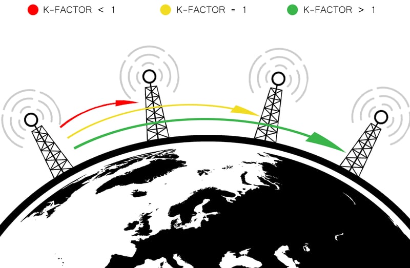
The k-factor represents the earth bulge atmospheric effect that impacts long distance communications. The refractivity of the atmosphere bends a beam, or signal, up or down, making it seem like the radius of the earth is less than or greater than the true radius. A k-factor of <1 means there is increased earth bulge and a shorter service range, and a k-factor of >1 means less earth bulge. The lower the k-factor is, the higher the towers need to be to successfully create a link that by-passes this earth bulge. The most common k-factor used for link profiles is 1.33, but weather can contribute to changing k-factor values. For example, storms create conditions for a lower k-factor and increased earth bulge.
Link profiles are only one component of the complex process of network planning. In following articles, we will discuss what viewsheds are and how they complement link profiles in the network planning process.
We at Intermap Technologies® are passionate about geospatial technology and its applications. In this series of blogs, we'll explore why earth observation data is critical to network planning by breaking down the key components of a successful link plan.

COMMENTS