
A viewshed refers to a calculation of the area that is visible from a specified point or location. This is very similar to a link profile, with the key difference being that a viewshed identifies obstructions and visibility in all directions away from one chosen point, whereas a link profile refers to what is visible within a single path between two specified points.
Viewshed analysis is the process of identifying which locations are visible from a given point and involves using elevation data from a digital elevation model (DEM) to identify potential obstacles blocking line-of-sight. Applications of a viewshed analysis in the telecommunications space include network planning and design.
Comparing Link Profiles & Viewsheds
As mentioned here, line-of-sight is used to evaluate if a link is possible between two points. While link profiles show point-to-point line-of-sight between transmitters, a viewshed shows line-of-sight visibility between a transmitter and multiple receivers in a given radius and direction.
Viewsheds are used in conjunction with link profiles in the process of network planning to evaluate terrain and determine network coverage. Link profiles are used when you are planning links between tower locations to evaluate the practicality of that link as the signal travels between antennas to reach its destination. Then, once the signal is at its destination, a viewshed is used to determine how far that signal can reach.
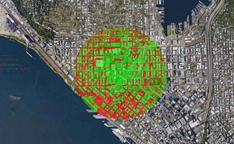
An example viewshed in Seattle. Green shows the visible area, and red shows obstructed line-of-sight.
Input Variables
Several variables are used to set parameters for a viewshed analysis:
- Transmitter Location: placement of the transmitter
- Transmitter Height: height of the tower above the ground or above the top of a building at the location of the transmitter
- Field (Receiver) Height: height at which the signal will be received in the area of the viewshed surrounding the transmitter
- Azimuth: angle range for calculation of the viewshed (i.e., 0 to 360 for a full circle, or smaller angle ranges for directional transmitters)
- Radius Value: range of the wireless signal
Signal Interference
Interference is important to consider when planning a network. As it is unavoidable, proactive steps can be taken to minimize this issue. Causes of interference can range from physical obstacles to environmental factors. Weather conditions may impact the performance of a signal; other factors include physical structures, such as buildings and trees. This is increasingly important as 5G grows more prevalent, as the signals used are higher in frequency and are more susceptible to being obstructed. A line-of-sight viewshed only provides one element of information in the assessment of signal interference, but it is imperative to know if an area is visible prior to assessing other signal interference parameters.
Accuracy
The accuracy of a viewshed analysis is affected by the resolution and detail of the underlying DEM. Since the analysis highlights potential obstructions caused by terrain and other surface features, more detailed data means that the there is more reliable input information on the potential obstacles, leading to improved assessment accuracy.
An accurate viewshed is important because it will help determine practical locations to place towers so that signals are able to reach the receiver and ensure that they are not blocked by surrounding obstacles. Additionally, they can help determine if a customer is in reach of your current services.
We at Intermap Technologies® are passionate about geospatial technology and its applications. In this series of blogs, we'll explore why Earth observation data is critical to network planning by breaking down the key components of a successful link plan.

COMMENTS