
A ground control point (GCP) is a feature with known real-world coordinates that can be clearly identified in an image. GCPs are used in the orthorectification process to augment the geometric parameters embedded in the raw image and improve the accuracy of the resulting orthorectification.
GCP Collection
There are several different ways that GCPs can be obtained, such as from ground survey, reference maps, or from an existing archive of features with known coordinates. During a ground survey, an identifiable feature is surveyed to obtain precise coordinates. The location can be any point on the ground that can be precisely identified at the resolution of the raw image. It is important to avoid non-permanent features, shadows, and repetitive features such as periodic lines along a road, as it may be difficult to uniquely identify the matching point in the raw image. GCPs can also be collected from reference maps (imagery that have already been orthorectified) to obtain the real-world coordinates. Results from previously completed surveys and existing publicly available data, such as airport runway coordinates, can be used for GCP collection as well.
Selecting GCPs
There are a couple of things to consider when selecting GCPs to ensure the best accuracy possible in the resulting orthorectification. First, the points need to be located on the ground with clear surroundings to make sure they are visible on the raw image. A point that is on the ground beside a tall object, such as a building or tree, will have a greater chance of being obstructed in the ortho-ready image. Selecting locations on flat ground also increases the expected accuracy of the digital elevation model (DEM) at the GCP’s location, and DEM accuracy is another key factor affecting quality of the orthorectification.
Second, it is important to choose a point that has high contrast with its surroundings to ensure you can precisely identify the point in the imagery. An example could be a road marking or the corner intersection of asphalt and concrete sidewalk, since there is high colour contrast.
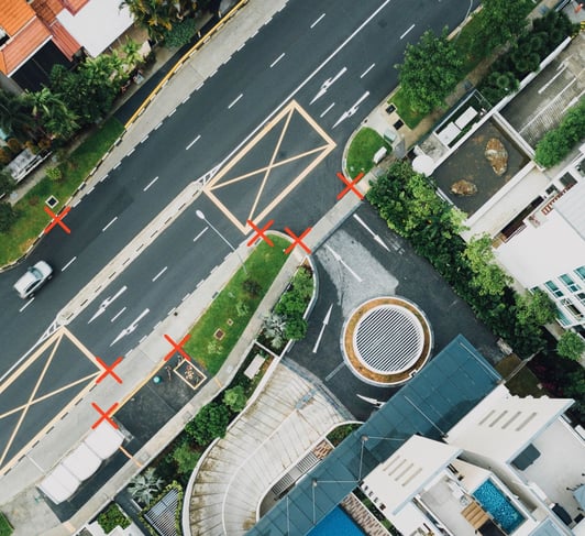
In the above picture, X's indicate points where there is high colour contrast.
In cases where the image to be orthorectified is not in the visible spectrum of light (such as infrared, ultraviolet, or radar) it may be necessary to ignore colour, and instead select a location for the GCP at the boundary between different surface materials to ensure the GCP is identifiable in the spectrum of the image.
Optimally selected GCPs can have a substantial positive effect on the resulting accuracy of orthorectification. Together with the image’s geometric parameters and a high accuracy DEM, GCPs are a vital component in ensuring the best orthorectification possible.
We at Intermap Technologies® are passionate about geospatial technology and applications. We work with numerous industries and process data to provide location-based answers. This blog series will highlight how geospatial data processing plays an important role in imagery applications.

COMMENTS