TelecommunicationsBannerSuggestion2019May15

NEXTWave Telecom

Model Your Wireless Network

Plan Point-to-Point Microwave and Millimeter Wave Wireless Systems

Our Telecom Solution Suite leverages the best available NEXTMap® datasets for network planning. With the 5G rollout and competitive wireless landscape, telecom companies need link planning with high-spatial detail, global coverage, and excellent vertical accuracy. We help telecom companies get a competitive edge by assisting in network planning decisions, ensuring service performance, and saving time and money.

ViewshedScreenshot_DouglasCounty
Intermap’s Viewshed product provides visibility and obstruction analysis based on NEXTMap One data. Simply specify transmitter and receiver height information to generate a detailed, colorized viewshed.

Key Features & Benefits

Powerful, Easy-to-Use Answers. Access information on demand from the cloud through easy to use web applications

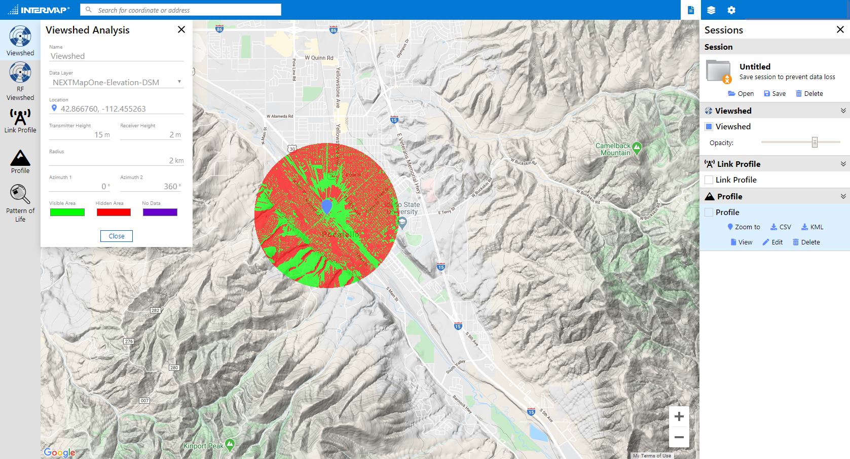
Fast. Create accurate viewsheds, custom maps, and line-of-sight analysis in just seconds

Worldwide Coverage. Telecom applications are available for all countries and locations worldwide

High-Resolution. Using NEXTMap One™ data, details such as building models and clutter are available at 1-meter resolution anywhere on the globe

Low-Cost. Get unlimited access to the information you need for a low monthly subscription

Cloud-Based API. Quickly access needed information or incorporate into your workflows

Bundled. Combine analytics with direct data availability to get quick answers and work with your RF planning software

Infrastructure Monitoring and Remote Sensing Webinar

Intermap participated in a webinar hosted by our partner, UP42. Nathan Mercer, a Software Engineer at Intermap, presented The Versatility of Viewsheds for Line-of-Sight Analysis. Other presenters included AiDash, which presented about using satellite data for vegetation management, and Catalyst, which presented about monitoring ground deformation along 1000s of kilometers of infrastructure. Check out the webinar replay to learn how remote sensing can be a replacement for ground-based infrastructure monitoring.

Viewshed analysis is a versatile visual tool used in a variety of industries for site assessment and selection. We discussed two types of viewsheds: Basic and RF. Basic viewsheds are used for site evaluation in renewable energy and construction projects and for UAV mission planning. RF viewsheds combine line-of-sight and radio frequency algorithms for signal propagation analyses in telecommunications. High-resolution digital elevation models are key in generating accurate viewsheds. We explored the many use cases of viewshed analysis and factors that affect the results.

Powerful NEXTWave™ Analytics

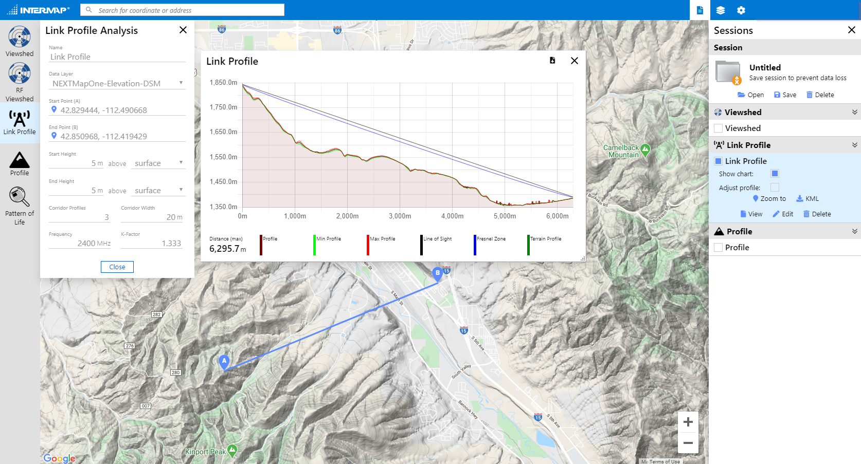
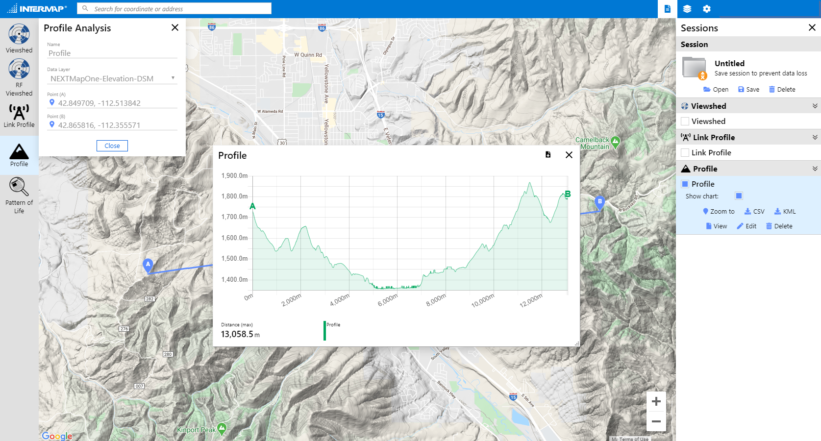
Intermap’s analytics offer instant access to detailed line-of-sight simulations.

  • Predict your network coverage for your customers on demand and eliminate unnecessary onsite crews
  • Calculate the last mile with our detailed viewshed analysis based on powerful 1-meter data
  • Plan your network using backhaul projections in our link profile application
  • Specify RF and environment characteristics such as frequency in order to calculate free space loss
  • Access detailed maps of terrain to quickly assess site suitability
NewAnalyticsImageSuggestion_2019May22


Access our digital elevation models, visualization and vector layer data, and analytics through our web applications

Link Profile App Screenshot

Link-Profile


Viewshed Screenshot

Viewshed


Profile Screenshot

Profile


Guatemala Clutter

High-Resolution Data

Perform your own modelling and analysis using our global 1-meter and 6-meter resolution datasets.

  • Digital surface model, including surface features such as buildings, trees, and obstacles
  • Digital terrain model with surface objects removed revealing the true bare earth terrain
  • 1-meter and 6-meter resolution datasets with fully classified clutter data showing roads, buildings, vegetation, and other features
  • Detailed clutter height information used to identify line-of-sight and propagation loss
  • Available on demand and compatible with telecom application software including Forsk Atoll, Infovista Planet, EDX Signal Pro, Siradel, Teoco Asset

Specifications

Analytics
Link Profile Analysis, Mass Link Profile, Viewshed Analysis, RF Viewshed
Data Model
DSM and DTM, 1m and 6m resolution, 1-3m LE90 accuracy (terrain dependent)
Building Models
65-90% of all buildings (depending on region)
Clutter Data
1m resolution, 7 clutter classes, 3m LE90 vertical accuracy (terrain dependent)
Mapping Overlays
Terrain hillshade
File Format
GeoTiff / BIL
Accessibility
API / Web application from Intermap’s cloud server
Compatibility
Data is compatible with major RF planning software including Forsk Atoll, Infovista Planet, EDX SignalPro, Teoco Asset, Siradel
Updates
Yearly updates available with subscription
License
Access is based on area and includes unlimited access to analytics (core package) and data (enhanced package)