This is the second post in my continuing series comparing InsitePro™ to RiskMeter Online™, Core Logic’s market leading solution. In the first post, I discussed the value of an interactive view of location-based risk compared to standard reports. In this post, I will explore a feature unique to InsitePro, but indispensable for underwriters or brokers trying to grasp the true exposure of a building or buildings to flood — terrain measuring.
InsitePro’s distance measuring tool is a quick and visual way to understand the spatial relationship between a building and sources of flooding, which puts flood zones into an empirical context instead of a modeled context. As with all models, flood models are never entirely accurate, and directly-measured information allows a user to better understand the inevitable limitations of flood models. Not only can the distance to a river or ocean be accurately determined, the height above (or more critically, below) can be measured.
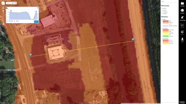
The elevation data being accessed with InsitePro is Intermap’s NEXTMap® USA digital terrain model (DTM), an ideal elevation dataset for this exact purpose. Elevations are ground elevations, with all surface features (buildings, trees, etc.) removed through a meticulous editing process. No other elevation dataset available in insurance tools are comparable.
In addition to ground elevations, InsitePro shows the user what the terrain looks like between two points of measurement. This is very valuable insight; viewing a profile of the ground between a building and a river (or coast) quickly tells you where water will flow if a flood does occur. Terrain profiles across rivers create detailed cross-sections that illustrate where water is most likely to break the banks, and profiles between a coastal property and the ocean allow quick visualization of any natural barriers that might exist but might not be modeled in storm surge models.
Using horizontal and vertical distances, as well as terrain profiles, in conjunction with flood maps reduces the uncertainty of specific risks. This directly saves money for InsitePro users, as uncertainty is expensive in underwriting and broking. There is more to flood risk than a flood zone.
Want to see how it works? See InsitePro's distance measuring tool in action in the following brief video.
Interested in learning more about the differences between InsitePro and RiskMeter Online? Download our free guide by clicking below.