As previously discussed, risk scoring is a powerful way to evaluate risk by including disparate and complex datasets, business rules, and experience — all prioritized and weighted — in an algorithm. While it’s not a new idea, it is underutilized. Therefore, I think it's worth looking at a few examples of how it's done. (Since it’s a vast subject, this post will concentrate on flood risk scoring.)
Topics: Insurance Underwriting, Risk Management, Flood Risk, Risk Scoring
It’s spring, which means one thing: The Flood Conference. Oh, it also means flooding in Hawaii, but that’s different.
Topics: Floods, Flood Risk, spring, Flood Conference
A tumultuous U.S. Nat Cat 2017 year bookended by huge first quarter losses from hail and tornado and an estimated $50bn+ insured losses from HIM (Harvey, Irma, and Maria) still did not impede the private flood insurance market from growing by 51.2% according to information referenced in an Insurance Journal article published on March 18th of this year. That news comes despite Congress’ delay in reform and reauthorization of the NFIP, currently +-$25 billion in debt (pre HIM).
Topics: Floods, Flood Insurance, Flood Risk, Private Flood
Feds Underestimating Flood Risk and ‘The Strangeness Index’
Posted by Bill Raymor on Mar 14, 2018 8:00:00 AM
PropertyCasualty360 published an article in December, 2017 that begins with this eye-opening quote, “Research conducted by a team of U.S. and U.K. scientists and engineers suggests that U.S. federal flood maps underestimate the number of Americans at risk for flood by more than 27 million people.”
A study from IOPscience gave a more onerous estimate of 41 million Americans living on the 100 year floodplain. And, with a value of $5.5 trillion! In contrast, current FEMA estimates are around 13 million Americans.
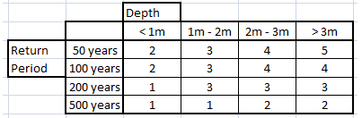
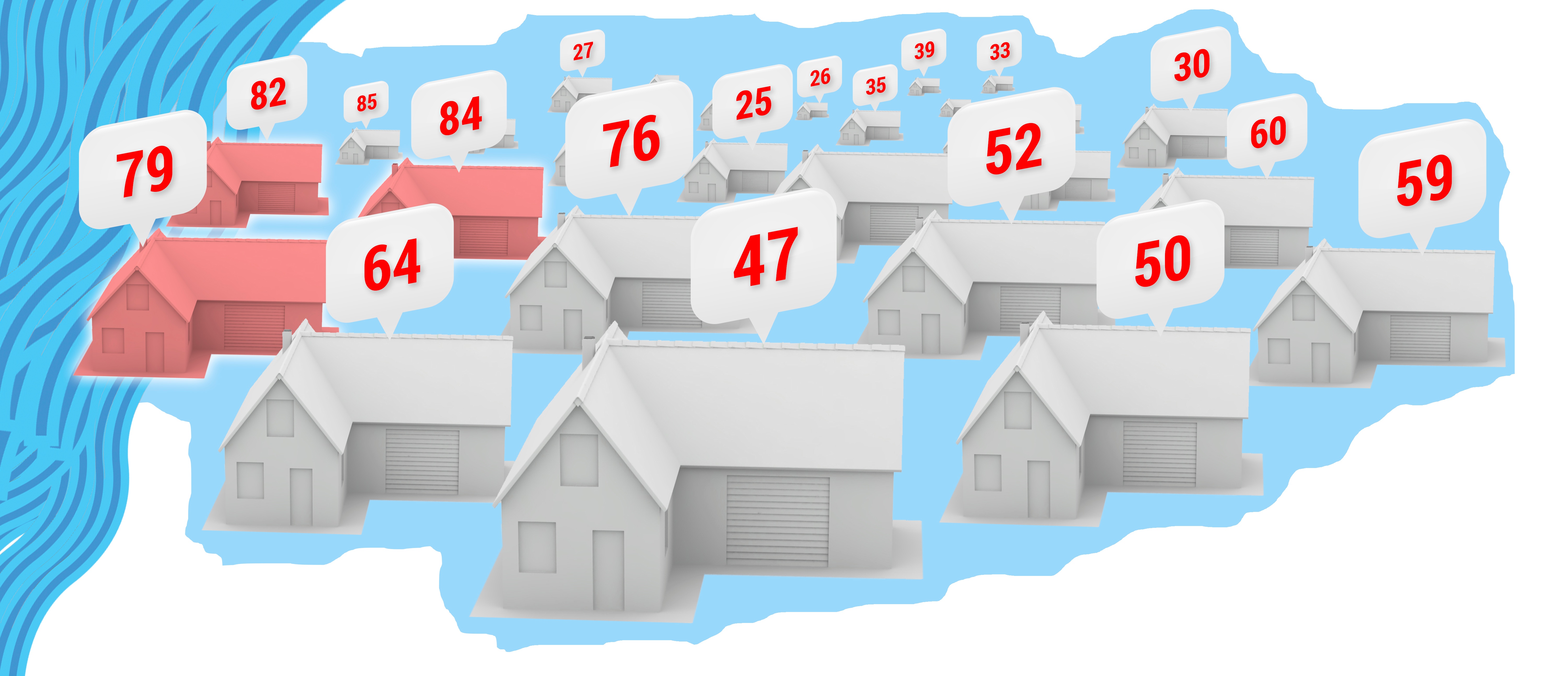
At the 2017 American Geophysical Union Meeting Dec. 11-15 in New Orleans, scientists presented a ‘redrawn’ flood map of the U.S. (coastal areas excluded) simulating every river catchment area. Intermap’s InsitePro flood mapping tool uses a mathematical tree structure called the Strahler Number to predict risk. It is a numbering system that correlates a numeric value to stream size from small tributaries to large riverways. The entire algorithm then uses our proprietary 5m seamless & contiguous bare earth elevation dataset to generate location specific flood risk scores.
Topics: Floods, Flood Insurance, Flood Risk, Risk Scoring, FEMA
Last week Insurance Journal ran a recap of the P/C Joint Industry Forum, held last month in NYC. If you underwrite flood or wildfire, go read it now and then come back here for a bit of commentary. If you are a blogger, chances are you have already read it.
Topics: Flood Insurance, Flood Risk, Insurance Protection Gap, FEMA