
It’s spring, which means one thing: The Flood Conference. Oh, it also means flooding in Hawaii, but that’s different.

It’s spring, which means one thing: The Flood Conference. Oh, it also means flooding in Hawaii, but that’s different.
Topics: Floods, Flood Risk, spring, Flood Conference
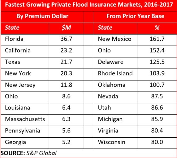
A tumultuous U.S. Nat Cat 2017 year bookended by huge first quarter losses from hail and tornado and an estimated $50bn+ insured losses from HIM (Harvey, Irma, and Maria) still did not impede the private flood insurance market from growing by 51.2% according to information referenced in an Insurance Journal article published on March 18th of this year. That news comes despite Congress’ delay in reform and reauthorization of the NFIP, currently +-$25 billion in debt (pre HIM).
Topics: Floods, Flood Insurance, Flood Risk, Private Flood
PropertyCasualty360 published an article in December, 2017 that begins with this eye-opening quote, “Research conducted by a team of U.S. and U.K. scientists and engineers suggests that U.S. federal flood maps underestimate the number of Americans at risk for flood by more than 27 million people.”
A study from IOPscience gave a more onerous estimate of 41 million Americans living on the 100 year floodplain. And, with a value of $5.5 trillion! In contrast, current FEMA estimates are around 13 million Americans.
At the 2017 American Geophysical Union Meeting Dec. 11-15 in New Orleans, scientists presented a ‘redrawn’ flood map of the U.S. (coastal areas excluded) simulating every river catchment area. Intermap’s InsitePro flood mapping tool uses a mathematical tree structure called the Strahler Number to predict risk. It is a numbering system that correlates a numeric value to stream size from small tributaries to large riverways. The entire algorithm then uses our proprietary 5m seamless & contiguous bare earth elevation dataset to generate location specific flood risk scores.
Topics: Floods, Flood Insurance, Flood Risk, Risk Scoring, FEMA

Modeling how a river will flood, or how the sea will rise over the shore, or how rain will accumulate and flood an area, is a tricky thing to do. The variables are limitless, and of course an act of nature is by definition unpredictable. Algorithms can get more and more complicated as these variables are accounted for in the model, but in the end it’s impossible to model things like trees accumulating under bridges to create ad hoc dams. What can really help a flood model’s quality is the foundation upon which it’s built: the empirical ingredients, like elevation data.
Topics: Floods, Risk Management, Flood Modeling

Way back at the beginning, we blogged about the different kinds of flood. Maybe we should have included winter flooding from ice floes. Granted, it is a variety of fluvial (or riverine) flooding, but there are some unique characteristics to this type of flooding.
Topics: Floods, Flood Modeling, Flood News
Welcome to The Risks of Hazard, brought to you by Intermap Technologies®. From the latest industry news and trends, to insight from thought leaders around the globe, stay tuned for a variety of content aimed at helping you better understand the role of location-based intelligence in the world of insurance underwriting and risk assessment.
To see how Intermap delivers analytics tailored to your underwriting, visit our InsitePro page.