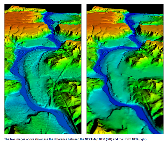
This continuation of my blog series comparing InsitePro™ to RiskMeter Online™ (read the first three posts here, here, and here) focuses on a key advantage of InsitePro: the availability of Intermap's best-in-class NEXTMap® five-meter digital terrain model (DTM).
When trying to understand the flood risk of a specific location, one of the most important aspects to consider is the shape of the terrain. Elevation data is the core ingredient in flood models, and it can be used to complement those flood models to enhance the results of a risk analysis. Having the best available elevation data is definitely important, and Intermap’s NEXTMap® DTM is a perfect fit.
Here are the top three reasons NEXTMap DTM is so well suited for flood risk analysis:
#2: It is a highly accurate and precise dataset. While LiDAR-derived elevation data is capable of higher precision, there is no large-area elevation data platform that can compare with IFSAR. Click here for more information on the specifications.
#3: It is a digital terrain model, showing bare-Earth elevations, which are the best elevation data for flood modeling and understanding how water is going to behave. The NEXTMap elevation data was originally a digital surface model (DSM), since the IFSAR senses the first surface it encounters — including trees and buildings. With proprietary geospatial production techniques, all the features on the surface of the Earth have been removed. The result is a high quality model of the actual ground. Intermap has built over 12,000,000 km2 of DTM (over 4,500,000 mile2) worldwide, making us an undisputed global leader in DTM elevation data.
There is no other elevation dataset available — commercially or otherwise — that can match NEXTMap DTM for flood risk analysis, and InsitePro leverages it in the United States and Europe. Ground elevations can be measured instantly, allowing quick comparisons with base flood elevations, river elevations, or to build a quick site plan of a location. The elevation measuring tool illustrates relative heights around a location, along with terrain profiles to demonstrate where water is most (and least) likely to flow.

Risk analysis based on models (for any peril) is never entirely certain, but one way to increase the certainty is to correlate multiple models. For flood and other peril analysis, InsitePro supports the use of two or more models, reducing the uncertainty of risk around locations with coherent results, and highlighting locations where deeper analysis is needed. For example, comparing results in the USA between FIRMs and a second independent flood model is a powerful analytic.
The combination of multiple models and superior elevation data is a strong combination to ensure InsitePro users get the best possible results by using the best possible information in the first place.
If you would like to learn more about the differences between InsitePro and RiskMeter Online, please download our free guide by clicking below.

