Ivan Maddox

Ivan Maddox is a Geomatics Engineer (University of Calgary, ’96), who has performed surveying and remote sensing projects all over the world. Before settling in Denver, he lived in Lyon, London, Montréal and Brisbane. He is the Product Manager for InsitePro at Intermap, and is the Executive Vice President for commercial solutions. When not leveraging data, Ivan enjoys leveraging the mountains, books, all things culinary, and playing with his kids.
Find me on:

Recent Posts

Innovation in the P & C Insurance Industry: What's holding us back?

Posted by Ivan Maddox on Jul 14, 2015 2:18:00 PM

Carrier Management published a great feature on innovation in P & C insurance last month (June 2015). Inside the Minds of Insurance Innovators explores the subject of innovation with a group of 16 leaders from different carriers, reinsurers, brokers, rating agencies, and (for good measure) a modeler, by asking each of them 11 questions. The questions and responses present an overall picture of how a 400+ year-old industry approaches the future at a time when the business and technology is changing faster than ever before, and the speed of change is still accelerating.  

There are some definite trends in the responses, and some complete outliers. I'd like to explore what these 16 industry thought leaders are telling us with a two-part series: In today's post I will focus on the consensus. Later in the week I will look at the not-so-universal responses, which are interesting of course because they're different.

Read More

Topics: Big Data, Insurance Underwriting, Risk Management

NRC Report Suggests Elevation Data is Important for Flood Risk (Go figure!)

Posted by Ivan Maddox on Jul 10, 2015 11:23:00 AM

The National Research Council (NRC) published a report in June that explored how FEMA’s National Flood Insurance Program (NFIP) appraises flood insurance in the U.S. It is a very thorough and technical document (as one would expect), that reaches ten conclusions on how NFIP can improve its pricing strategies to become, essentially, more solvent. The conclusions focus on different aspects of how a policy price is determined, including the use of loss/claims data, the risk analysis, flood modeling techniques, damage and exposure estimations, replacement costs, and other factors. One conclusion stood out for me, and I wasn’t alone.

Read More

Topics: Flood Insurance, Risk Management, Flood Risk

APIs: The LEGO Blocks of Modern Business Software Solutions

Posted by Ivan Maddox on Jul 7, 2015 11:28:00 AM

These days, business software (and technology in general) evolves faster than ever before. Users have access to rapidly improving analytics based on huge datasets; flexibility on how questions are asked; and — most importantly — how answers are received and interpreted.

In the past 10 years or so, business systems have moved from desktop-based programs to much more dynamic applications that are simultaneously more specialized and more universal. Business solutions now leverage more data to deliver answers that are very specific to an industry, to an organization, and to specific users. There are several technological cornerstones that make today’s systems so powerful, and one of them is the Application Programming Interface, or API.

How do APIs play such a big role in today’s software? Well, they're like LEGO blocks.

Read More

Topics: cloud computing, Insurance Software

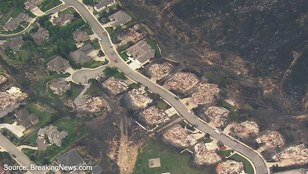
Do property insurers have wildfire covered?

Posted by Ivan Maddox on Jun 30, 2015 3:39:14 PM

Summer is here, and in the Pacific Northwest and Western Canada, it really feels like it. Record highs are being set all over the region, the Calgary Zoo is closed so the animals can be cooled, and the wildfires are burning.

The most newsworthy wildfire so far is the Sleepy Hollow wildfire in Wenatchee, WA. It's burning homes and industrial buildings, and as of today is only 10% contained. It will get bigger before it gets smaller.

Read More

Topics: Natural Hazard Risk, Insurance Underwriting, Wildfire, Other Risk Models

It's Not Every Day the USA Gets a New Flood Model

Posted by Ivan Maddox on Jun 26, 2015 11:16:00 AM

Today is a big day for Intermap and for InsitePro — we are releasing FloodScope™ USA, the only flood model available that is built on a contiguous, manually-edited digital terrain model (DTM) for the lower 48 states and Hawaii.

As I've discussed before, elevation data is a key input into any flood model, so the ability to leverage a high quality DTM at full resolution is a significant achievement. Starting today, insurers can use flood zone determinations as a part of their analytics to better understand the risk of river flooding.

Read More

Topics: InsitePro, Risk Management, Flood Modeling, Flood Risk

The Risks of Hazard Blog   rss-feed

Welcome to The Risks of Hazard, brought to you by Intermap Technologies®. From the latest industry news and trends, to insight from thought leaders around the globe, stay tuned for a variety of content aimed at helping you better understand the role of location-based intelligence in the world of insurance underwriting and risk assessment.

To see how Intermap delivers analytics tailored to your underwriting, visit our InsitePro page.

Subscribe to the Risks of Hazard blog!