Ivan Maddox

Ivan Maddox is a Geomatics Engineer (University of Calgary, ’96), who has performed surveying and remote sensing projects all over the world. Before settling in Denver, he lived in Lyon, London, Montréal and Brisbane. He is the Product Manager for InsitePro at Intermap, and is the Executive Vice President for commercial solutions. When not leveraging data, Ivan enjoys leveraging the mountains, books, all things culinary, and playing with his kids.
Find me on:

Recent Posts

Terrain Data and Pipelines: Thoughts From a Bike

Posted by Ivan Maddox on Jan 9, 2015 2:39:00 PM

Today we decided to unlock the Intermap blog vault to revisit a a past post written by a former employee, Ryan Hamilton. His thoughts on pipeline safety and the relationship to terrain data were written a little more than a year ago, but are more relevant than ever as we roll out our new product targeted to this very industry — InsitePro for Pipelines™. 

Read More

Topics: Pipeline Operations, Terrain Data

Peril, risk, and hazard: What’s the difference?

Posted by Ivan Maddox on Dec 12, 2014 10:57:00 AM

Peril, risk, and hazard are three words used frequently in my business. And according to the Oxford English Dictionary, they have very similar definitions:

  • Peril: Serious and immediate danger. 
  • Risk: Situation involving exposure to danger. 
  • Hazard: Danger or risk.  

You could get away with interchanging these words in day-to-day conversation. But in insurance and financial circles, they each have a distinct meaning and it’s important to understand their differences. 

Read More

Topics: Natural Hazard Risk, Risk Management

What is a cat model?

Posted by Ivan Maddox on Dec 5, 2014 10:34:00 AM

Property insurers rely on many types of tools for risk analysis, but none quite so complex as the cat model. Short for catastrophe, cat modeling uses computer-assisted calculations to estimate the losses that could be sustained due to a catastrophic natural event. Perils analyzed include flood, hurricane (wind damage and storm surge), earthquake, tornado, hail, wildfire and winter storm. The principle function of cat models is to help insurers prove their financial solvency. 

Read More

Topics: Natural Hazard Risk, Natural Catastrophe, Other Risk Models

Flood Insurance Models Around the World

Posted by Ivan Maddox on Dec 3, 2014 10:20:00 AM

Flood poses risk to property and productivity on every continent, and most developed countries have flood insurance available to mitigate that risk. However, everywhere you go, the flood insurance market is different.

Read More

Topics: Flood Insurance, Insurance Underwriting, Flood Modeling

Why FEMA Flood Maps Don't Tell the Whole Risk Story

Posted by Ivan Maddox on Dec 3, 2014 10:09:00 AM

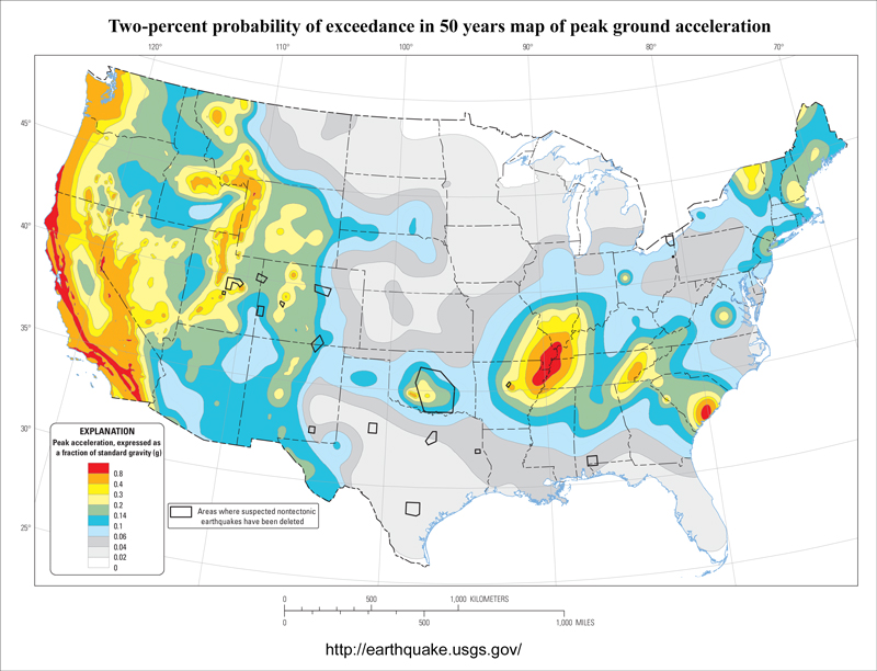
When it comes to flood risk, the Federal Emergency Management Agency (FEMA)'s Flood Insurance Rate Maps (FIRMs) are the authority — and rightly so. They have decades of engineering intelligence built into them and are refined regularly. In the end, though, they are based on flood models, and as statistician George Box famously wrote, "essentially, all models are wrong, but some are useful."

A recently published report that investigated how well the FIRMs predicted flooding from Superstorm Sandy in 2012 illustrates that while they performed well in some areas, there is also room for improvement. That's because there is no flood model, or model of any natural catastrophe, that will be 100% accurate. In fact, predicting 100% of a flood event is usually a sign of a weak flood model: Imagine a model where everything within 100 miles of water is labeled as High Risk. Flood models display their quality in the zone between, “You don’t need a model to know that’s a flood risk” and “that place will never flood”. In statistical terms, the sweet spot is around 75% or 80% of flooding predicted. This is about where FEMA's FIRMs were on Sandy, but there is more to understanding flood risk than statistics.

Read More

Topics: InsitePro, Flood Modeling, Flood Risk

The Risks of Hazard Blog   rss-feed

Welcome to The Risks of Hazard, brought to you by Intermap Technologies®. From the latest industry news and trends, to insight from thought leaders around the globe, stay tuned for a variety of content aimed at helping you better understand the role of location-based intelligence in the world of insurance underwriting and risk assessment.

To see how Intermap delivers analytics tailored to your underwriting, visit our InsitePro page.

Subscribe to the Risks of Hazard blog!